Basic HTML Version


Description of Surveyed Area – Ecoregions
6
Ecoregions
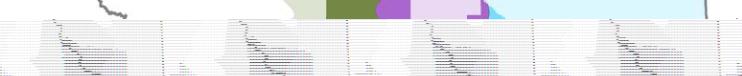
The irrigation districts surveyed are located in three grassland ecoregions
(Figure 2). Ecoregions are areas of
similar landforms, climate, natural vegetation, soils and land use.
The
Fescue Grassland Ecoregion
lies in the Rocky Mountain foothills, in the area subject to winter chinooks. It is
dominated by rough fescue, needle-and-thread grass and low-growing forbs. The ecoregion is undulating to rolling
with glacial till and lacustrine deposits, underlain by sandstone and shale. The dominant soil is a Black Chernozem.
Northern portions are almost entirely cultivated; southern portions are cultivated on the more level areas.
The
Moist Mixed Grassland Ecoregion
includes the most northern area of open grassland in the prairies. Native
vegetation, where it remains, is dominated by spear grass, wheat grass and deciduous shrubs such as chokecherry
and wolf willow. The ecoregion is composed of hummocky to kettled glacial till and level to very gently undulating
lacustrine deposits. Dark Brown Chernozemic soils predominate, with significant areas of Solonetzic soils in
eastern Alberta. Much of the ecoregion is in agricultural production.
The
Mixed Grassland Ecoregion
is part of the semiarid shortgrass prairie. Native vegetation is dominated by spear
grass, blue grama grass, and wheat grass. The ecoregion is composed of dissected to kettled glacial till, undulating
to dissected lacustrine sediments and hummocky Eolian deposits. Soils are predominantly Brown Chernozems.
Cultivated land covers about half of the ecoregion.
Irrigated areas surveyed in
Fescue Grassland Ecoregion
Moist Mixed Grassland Ecoregion
Mixed Grassland Ecoregion
Calgary
Brooks
Medicine Hat
Lethbridge
Glenwood
Figure 2.
Area surveyed in ecoregions included in the weed survey.
10
Ecological Stratification Working Group
. 1995. A National Ecological Framework for Canada. Agriculture
and Agri-Food Canada, Research Branch, Centre for Land and Biological Resources Research and
Environment Canada, State of the Environment Directorate, Ecozone Analysis Branch, Ottawa/Hull. Report
and national map at 1:7 5000 000 scale.